mapping
Regional
Mapping from the Thompson
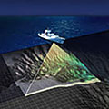
The R/V Thomas G. Thompson is equipped with an EM300 high-resolution multi-beam echosounder, a type of sonar, which is able to discern features larger than 50 meters. The EM300 is mounted on the hull of the ship and sends out an array of multiple beams that cover a swath of the ocean floor at a 135 degree angle. The total swath it measures on the seafloor equals two times the water depth. If the average depth along the Juan de Fuca Ridge segment is 2200 meters, the EM300 can map an area that is 4,400 meters in width. This can be very useful on a regional scale, such as the Juan de Fuca tectonic plate.
Limitations
The EM300, however, cannot register the fine detail needed to see a hydrothermal vent field. Although, there may be an array of several beams, each will take an average depth reading at its 50-meter area. If a chimney happens to be within that area, it will be averaged in with the other features. For instance, imagine you are in a plane looking at the topography below you. You can see the mountains, hills, rivers, and even cars. How well can you make out the people below? Probably not very well. Now imagine looking for a hydrothermal vent field. The vent can be compared to the people you are trying to make out when using the EM 300.